Following Jacob's death (circa 1847), his land was divided among his six surviving children: Elizabeth Eflin, Rebecca Albright, Sarah P. Albright (#28), Daniel Albright, George Albright and William Albright. Below is a portion of the legal document describing in detail how tracts of land were to be divided. Scanned copies of pages posted on ancestry.com did not appear to be in order. Additionally, there were alternative versions of some pages. The webmaster attempted to arrange the more legible pages in chronological order below. Below each image of an original document page is a transcription written by the webmaster in October 2016. [Note: There seem to be several differences in the descriptions of the properties and in the amounts required to be paid by some of the heirs to others to balance the value of their inheritance on the various pages. ]
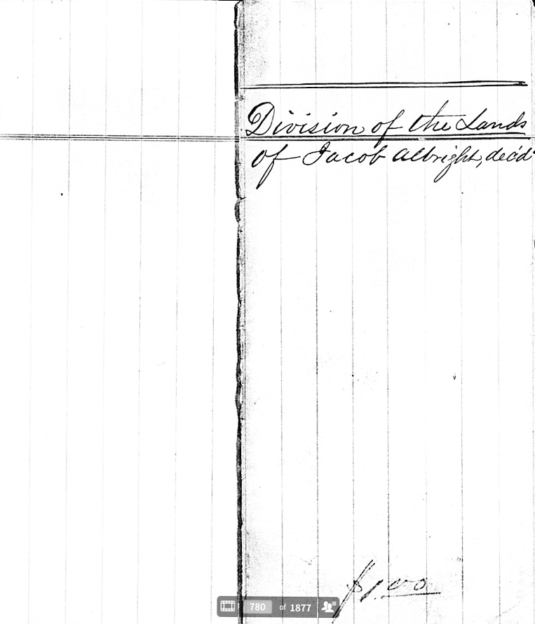
Page 1: Division of the Lands
of Jacob Albright, dec’d.
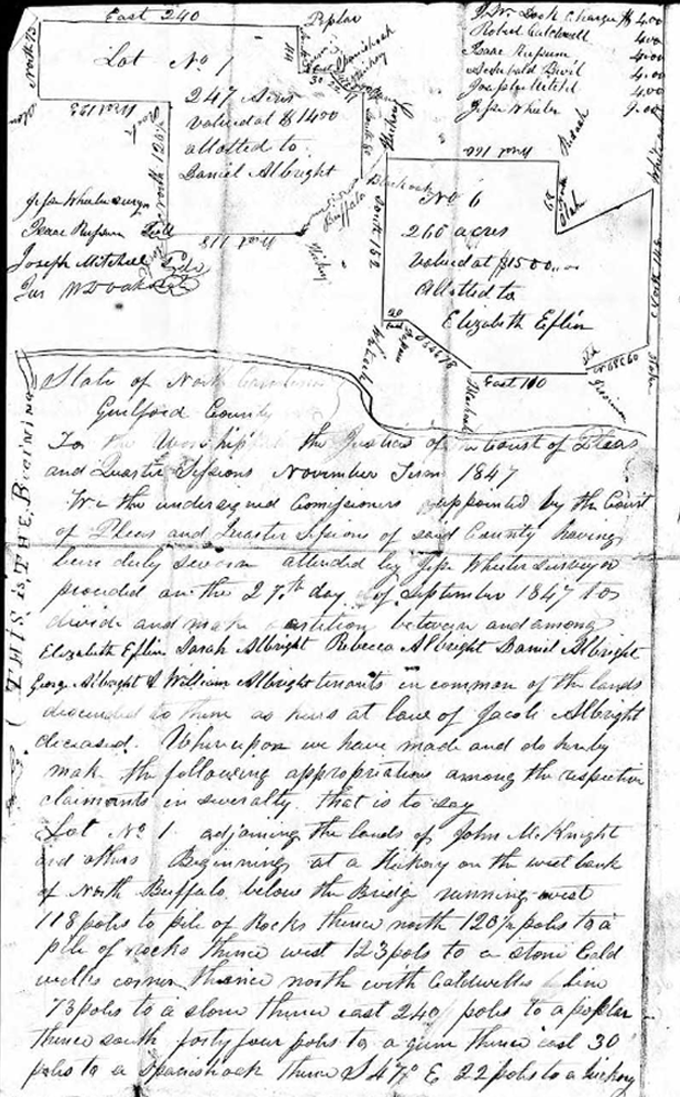
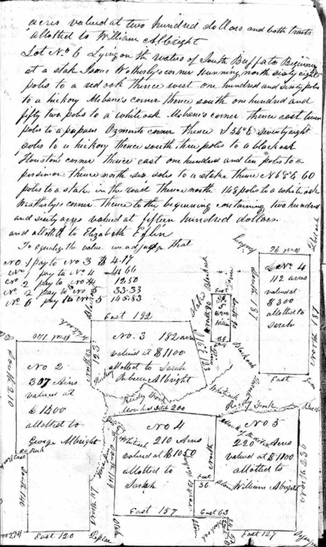
[Note: The top of this page shows descriptive maps of lots No 1 and 6. Bordering the maps are the names of people presumed to be neighbors, dimensions of each lot, and the location of landmarks like trees. Many details cannot be read.] [Note: Line spaces not in the original document were added in this transcription to separate Lot No descriptions.]
Lot No. 1
247 acres
valued at $1400
allotted to Daniel Albright.Lot No. 6
260 acres
valued at $1500
allotted to Elizabeth Eflin.State of North Carolina
Guilford CountyTo the Worship the Justices of the Court of Pleas
and Quarter Sessions November Term 1847We the undersigned Commissioners appointed by the Court
of Pleas and Quarter Sessions of said County having
been duly sworn attended by [?] Wheeler [during ] [?]
[proceded] on the 27th day of September 1847 to
divide and make [?] between and among
Elizabeth Eflin Sarah Albright Rebecca Albright Daniel Albright
Georg. Albright & William Albright tenants in common of the lands
descended to them as heirs at law of Jacob Albright
deceased. Whereupon we have made and do hereby
make the following appropriations among the respective
claimants in severalty that is to say
Lot No. 1 adjoining the lands of John McKnight
and others Beginning at the Hickory on the west bank
of North Buffalo below the Bridge running west
118 poles to pile of rocks therece north 120 1/2 poles to a
pile of rocks thence west 123 pols to a stone [?]
[?] corner thence north with Caldwells [?]
73 poles to a slow [?] east 240 [poles to a poplar
[thence] south forty four poles to a gum tree east 30 ‘
poles to a Spanish oak [? ] [?] 22 pols to a hickory
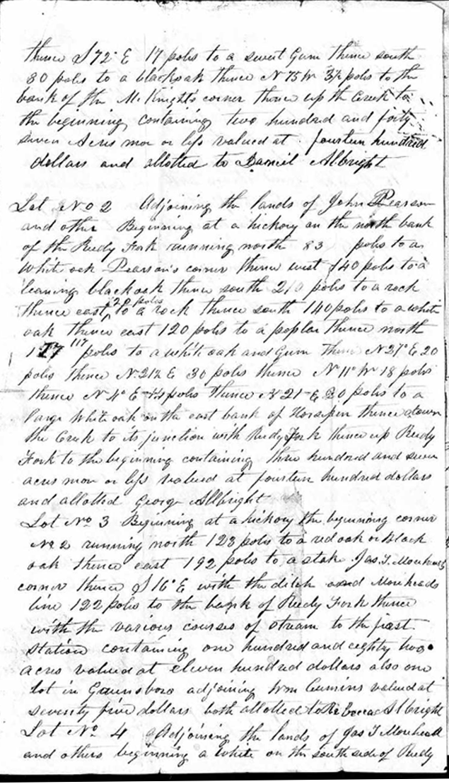
thence S 72º E 17 poles to a sweet gum thence south
80 poles to a black oak thence N 75 [?] 3 1/2 poles to the
bank of the McKnight’s corner thence up the Creek to
the beginning containing two hundred and forty
seven acres more or less valued at fourteen hundred
dollars and allotted to Daniel AlbrightLot No 2 Adjoining the lands of John Pearson
and others Beginning at a hickory on the north bank
of the Reedy Fork running north 83 poles to a
White oak Pearson’s corner thence west 140 poles to a
leaning black oak thence south 210 poles to a rock
thence east 120 poles to a rock thence south 140 poles to a white
oak thence east 120 poles to a poplar thence north
117 poles to a white oak and gum thence N 27º E 20
poles thence N 212 E 30 poles thence N 11º [?] 18 poles
thence N [?] º E [?] poles thence N 21 E 20 poles to a
large White oak on the east bank of [?] thence [down]
the Creek to its junction with Reedy Fork thence up Reedy
Fork to the beginning containing three hundred and seven
acres more or less valued at fourteen hundred dollars
and allotted George AlbrightLot No 3 Beginning at a hickory tree beginning corner
No 2 running north 123 poles to a red oak or black
oak thence east 192 poles to a stake. Jas. Fellowhead
corner thence S 16º E with the ditch and Moreheads
line 122 poles to the bank of Reedy Fork thence
with the various courses of stream to the first
station containing one hundred and eighty two
acres valued at eleven hundred dollars also one
lot in Greensboro adjoining Wm Cumins valued at
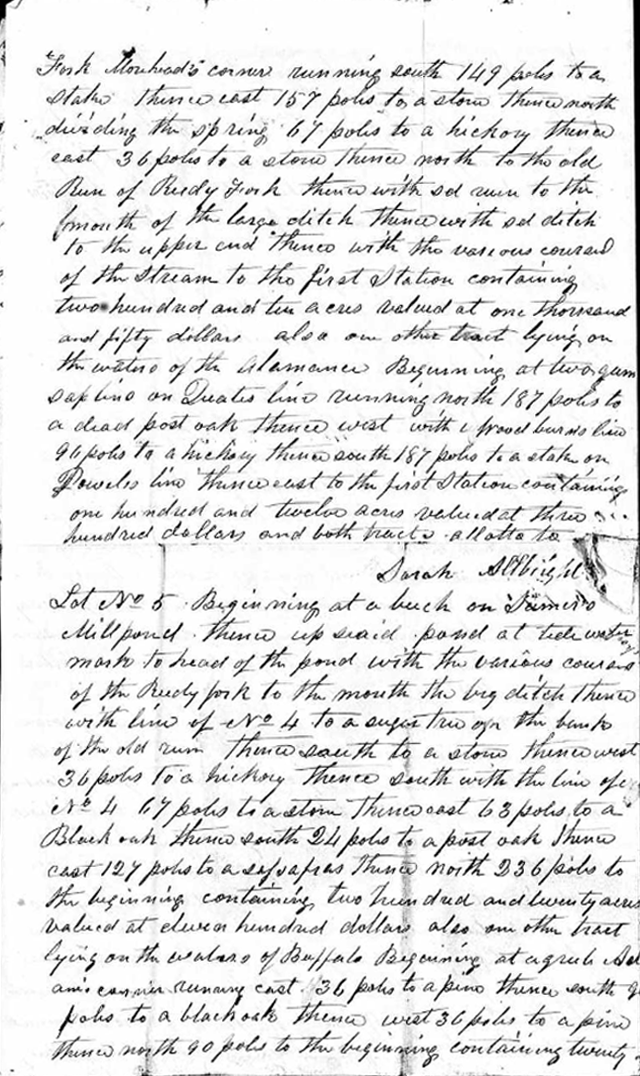
seventy five dollars both allotted to Rebecca AlbrightLot 4 adjoining the lands of Jas Fellowhead
and others beginning [?] on the south side of Reedy
Fork Morehead’s corner running south 149 poles to a
stake thence east 157 poles to a stone thence north
dividing the spring 67 poles to a hickory thence
east 36 poles to a stone thence north to the old
Run of Reedy Fork thence with [?] run to the
mouth of the large ditch thence with [?] ditch
to the upper and thence with the various courses
of the Stream to the first Station containing
two hundred and ten acres valued at one thousand
and fifty dollars also one other tract lying on
the waters of the Alamance Beginning at two gum
sap line on [?] line running north 187 poles to
a dead post oak thence west with [?] Woodburn’s line
96 poles to a hickory thence south 187 poles to a stake on
Powales line thence east to the first station containing
one hundred and twelve acres valued at three
hundred dollars and both tracts allotted to
Sarah AlbrightLot No 5 Beginning at a beech on Sumer’s
Millpond thence up said pond at tide water
mark to head of the pond with the various courses
of the Reedy Fork to the mouth the big ditch thence
with line of No 4 to a sugar tree on the bank
of the old run thence south to a stone thence west
36 poles to a hickory thence south with the line of [?]
No 4 67 poles to a stone thence east 68 poles to a
Black oak thence south 24 poles to a post oak thence
east 127 poles to a sassafras thence north 236 poles to
the beginnings containing two hundred and twenty acres
valued at eleven hundred dollars also one other tract
lying on the waters of Buffalo Beginning at a [?] [?]
[?] [?] running east 36 poles to a pine thence south [?]
poles to a black oak thence west 36 poles to a pine
thence north 90 poles to the beginning containing twenty
acres valued at two hundred dollars and both tracts
allotted to William AlbrightLot No 6 Lying on the waters of South Buffalo Beginning
at stake Isaac Wetherly’s corner running north sixty eight
poles to a red oak thence west one hundred and sixty poles
to a hickory Mebane’s corner thence south on hundred and
fifty two poles to a white oak. Mchane’s corner thence east [?]
poles to a papau Ozmact’s corner thence S 54º E seventy eight
poles to a hickory thence south three poles to a black oak
Houston’s corner thence east one hundred and ten poles to a
[?] thence north [?] poles to a stake thence N 68º E 60
poles to a stake in the road thence north 168 poles to a white oak
Weatherby’s corner thence to the beginning containing two hundred
and sixty acres valued at fifteen hundred dollars.
and allotted to Elizabeth EflinTo Equalize the value we adjudge that
No 1 pay to No 3 $4.17
No 1 pay to No 4 4.66
No 2 pay to No 4 12.50
No 2 pay to No 5 53.33
No 6 pay to No 5 145.83[Note: The bottom of this page shows descriptive maps of lots No 2 -5. Bordering the maps are the names of people presumed to be neighbors, dimensions of each lot, and the location of landmarks like trees. Many details cannot be read.]
No 2
307 acres
valued at $1400
allotted to George AlbrightNo. 3
182 acres
valued at $1100
allotted to Sarah Rebecca Albright [Note: The webmaster does not know why both Sarah and Rebecca are listed for this piece of land here. In the description earlier, Only Rebecca is listed for tract No. 3. According to a preceeding description, Rebecca also received a lot in Greensboro valued at $75].No. 4
112 acres
valued at $ 300
allotted to Sarah
another No 4 tract
210 acres
valued at $1050
allotted to SarahNo 5
valued at 67.00
allotted to William,
another No 5 tract
220 acres
valued at $1100
allotted to William Albright
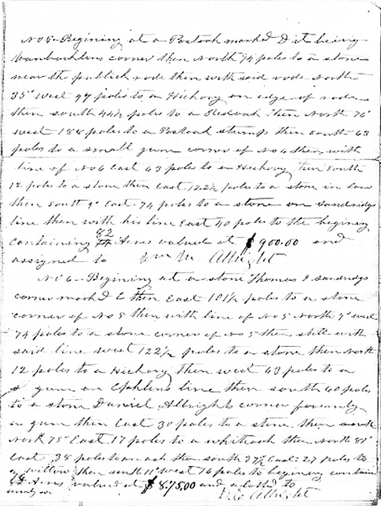
No 5 Beginning at a [?] marked D it being
Vanbachlens corner then north 94 poles to a stone
near the publick rode then with said rode south
35º west 47 poles to a Hickory on edge of rocks
then south 44 1/2 poles to a [Redwood] then north 76º
west 188 poles to a [?] stump then south 63
poles to a small gum corner of No 6 then west
line of No 6 east 43 pole to a Hickory turn south
12 poles to a stone then east 122 1/2 poles to a stone in [?]
then south 4º East 74 poles to a stone on [?]
line then with his line east 110 poles to the begining
containing 82 acres valued at $900.00 and
assigned to Wm M. AlbrightNo 6 - Beginning at a stone Thomas [?]
corner mark & then east 101 1/2 poles to a stone
corner of No 5 then with line of No 5 North 9) [west]
74 poles to a stone corner of No 5 then still with
said line west 122 1/2 poles to a stone then north
12 poles to a Hickory then south 60 poles to a
[?] gum on Ephlens line then south 60 poles
to a stone Daniel Albrights corner formerly
a gum then East 30 poles to a stone then south
north 75º East 17 poles to a white oak then north 87º
East 38 poles to an ash then south 37 1/2 east 27 poles to
[?] willow then south 11º West 76 poles to begining containing
seventy six acres valued at $875.00 and allotted to
C. Albright
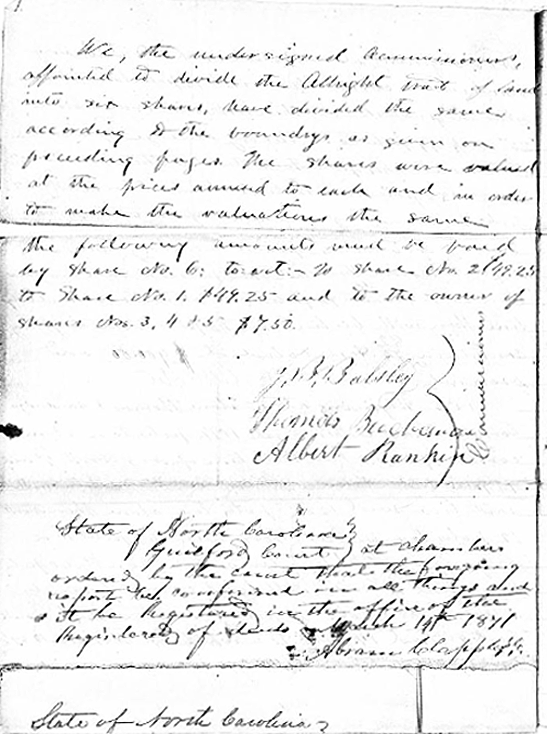
We, the undersigned Commissioners
appointed to divide the Allbright tract of land
into six shares, have divided the same
according [D] the boundrys as given on
preceeding pages The shares were valued
at the prices [?] to each and in order
to make the valuations the same
the following amounts must be paid
by share No. 6: to wit - [?] share No 2 $49.25
to Share No. 1. $49.25 and to the owner of
share No. 3, 4 & 5 $7.50.Commissioners
B. Balsley
Thomas Buchanan
Albert RankinState of North Carolina
Guilford Court at Chambers
ordered by the court that the foregoing
report be [confirmed] in all things and
it be Registered in the office of the
Registerer of Deeds November 14th 1847
[Abra???] Clapp [?]State of North Carolina
Contact person for this website is Susan Snyder: susanleachsnyder@gmail.com