Gabriel Steely (#93)'s Land Patents
THE OFFICIAL LANDS BOOK written by Dr. George W. Knepper is a short history of original land treaties, grants, surveys and subdivisions. It is a publicaton of The Auditor of the State of Ohio, Jim Petro. The first paperback edition is dated 2002. [Note: The blue-typed information below is from this book].
"On May 20, 1785, Congress enacted a land ordinance which became one of the most significant pieces of legislation ever passed by the federal legislature. The Land Ordinance of 1785 created rules for the orderly survey, sale, and settlement of the public domain, with settlement to occur only on surveyed land. Land ceded by the states and purchased from the Indians was to be divided into six mile square townships created by lines running north and south intersecting at right angles with east-west lines. Townships were to be arranged in north-south rows called ranges. Most townships were to be subdivided into 36 one mile square sections. Each range, township, and section was to be numbered in a regular, consistent sequence."
"In the Land Act of 1796, sections were to be numbered so that section 1 was located in the township's northeast corner. Numbers would then progress west and east alternately through the township, with progressive numbers until number 36 was reached in the township's southeast corner."
One-seventh of the land was used by the Secretary of War to compensate veterans of the Continental army with land warrants (bounty lands). Originally, a section (one square mile or 640 acres) was the smallest unit for sale. The purchaser was called an "entryman." The first document recording a sale of a piece of land from the government was called a land patent.
The Land Act of 1800 established federal land offices in Steubenville, Marietta, Chillicothe, and Cincinnati. Land office business was now more readily accessible to potential purchasers like Gabriel Steely, the webmaster's G-G-G-G-G Grandfather. The new law provided for sale at auction, and the minimum price was set at two dollars per acre. There were payment credit plans available. It is unknown whether or not Gabriel used the credit system. In 1820, Congress abolished the credit system, but the price was reduced to $1.25/acre.
"The purchase of federal land was a bureaucratic process in the early nineteenth century. Once a purchaser (entryman) paid for his land, the registrar of the land office issued a final certificate (or certificate of location if land scrip was used in the purchase). The final certificate was then sent to federal authorities in Washington D.C. and a U.S. Patent was issued. Accounts and records had to be verified, thus extending the process. Until March 1833,each U.S. Patent was signed by the President of the United States. The patent was then returned to the originating land office to be delivered to the owner (patentee)."
_________________________________________________
Five patents were issued by President Thomas Jefferson, President James Madison, or the Commissioner of the General Land-Office for land purchased by Gabriel Steely (#93) in 1805 and 1806.
In January 2019, David Duncan, a G-G-G-G-G Grandson of Gabriel Steely downloaded these land patents (posted below) from the U.S. Department of Interior of Land Management Website (General Land Office Records). Below each scanned patent is a transcription of same, written by the webmaster.
The chart below shows the date of each patent, the date of the land purchase, section, township, and range. By clicking on the dates in blue, you will be taken directly to each patent document. The map below the chart shows the location of each of the land parcels by number. [Note: All properties are near one another in Township #10, Range # 21.]
| Date of Patent | Date of Purchase | Section | Township | Range | |
| (1) | Feb 17, 1806 | Unknown | 29 NW Quarter | 10 | 21 |
| (2) | Feb 18, 1806 | July 29, 1805 | 20 NW Quarter | 10 | 21 |
| (3) | Aug 7, 2012 | Oct 26, 1805 | 20 SW Quarter | 10 | 21 |
| (4) | Aug 7, 2012 * | July 31, 1805 | 20 NE Quarter | 10 | 21 |
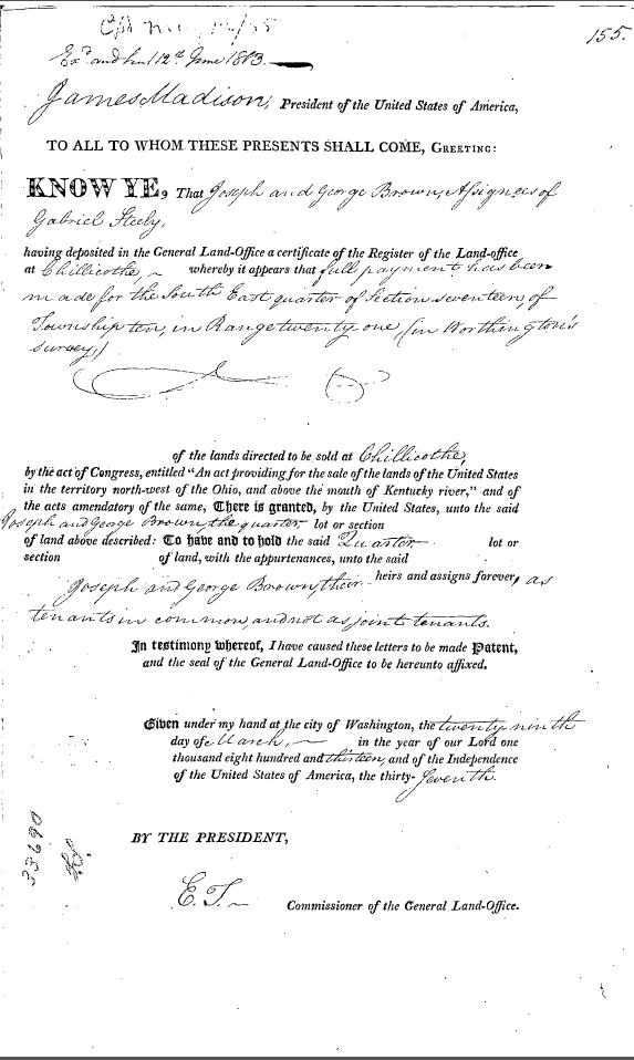
| (5) | Mar 29, 1813** | Sep 27, 1806 | 17 SE Quarter | 10 | 21 |
* This patent was given to Gabriel's son (John Steely)
** This patent was given to Joseph and George Brown (assigners of Gabriel)
_________________________________________________
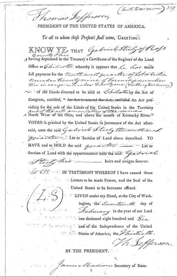
(1) Document Scan: "Ohio River Survey: Section 29 NW 1/4
Pickaway, County, February 17, 1806"
Transcript of Document: "Ohio River Survey: Section 29 NW 1/4
Pickaway, County, February 17, 1806"
_________________________________________________
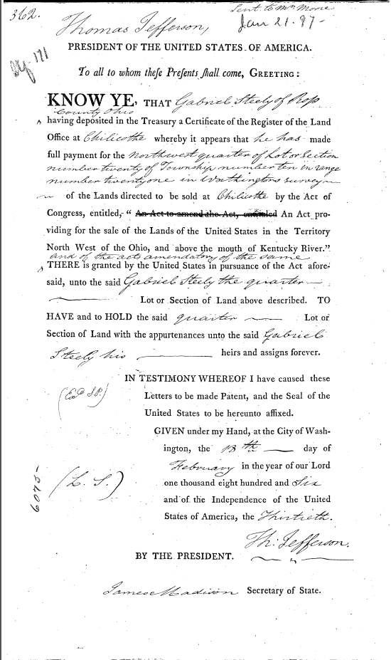
(2) Document Scan: "Ohio River Survey Section 20 NW 1/4
Pickaway, County, February 18, 1806"
Transcript of Document: "Ohio River Survey: Section 20 NW 1/4
Pickaway, County, February 18, 1806"
_________________________________________________
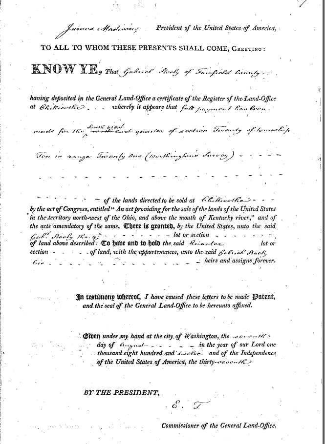
(3) Document Scan: "Ohio River Survey Section 20 SW 1/4
Pickaway, County, August 7, 1812"
Transcript of Document: "Ohio River Survey Section 20 SW 1/4
Pickaway, County, August 7, 1812"
_________________________________________________
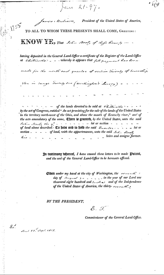
(4) Document Scan: "Ohio River Survey Section 20 NE 1/4
Pickaway, County, August 7, 1812"
Transcript of Document: "Ohio River Survey Section 20 NE 1/4
Pickaway, County, August 7, 1812"
_________________________________________________
(5) Document Scan: "Ohio River Survey Section 17 SE 1/4
Pickaway, County, March 29, 1813"
Transcript of Document: "Ohio River Survey Section 17 SE 1/4
Pickaway, County, March 29, 1813"
Contact person for this website is Susan Snyder: susanleachsnyder@gmail.com